

52 ~ Γκάμπριελ Βέλτερ: Troizen und Kalaureia
Das Land Troizen ist demnach eine geophysische Einheit, welde den gesamten Aderesgebitgszug nebst die ihm im Norden und Süden vorgelagerten Küstenebenen umfaßt. An der nördlichen und ausgedehntesten von ihnen liegt die Stadr Troizen (Taf I).
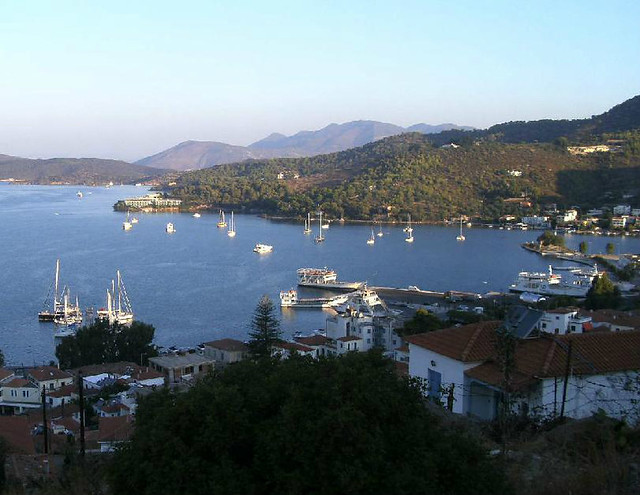
Der Ansatz der Halbinsel Methana an das Festland teilt die Nordküste des Landes Troizen in einen östlichen und einen westlichen Abschnitt. Dem östlichen ist im Abstand einer halben Meile die Insel Kalaureia, jetzt Poros, vorgelagert, wodurch ein langgestreckter ausgezeichneter Naturhafen entsteht, dessen westlicher Teil Πώγων hieß (Herodot VIII 42; Strabo II 6,14; Mela II 3). Er hat swei Sugänge, einen im Osten, wo Kalaureia nur durch einen engen und seichten Sund vom Festland gettennt ist, und einen breiteren am westlichen Ende von Kalaureia. Weiter östlich liegen dicht an der Küste zwei unbedeutende Riffe und eine kleine Insel mit einer vom bayerischen Oberst Heydeck im Jahre 1828 errichteten Befestigung (vgl. Fasti S. 7r). Vor dem Kap Skyllaion liegen swei kleine unbewohnbare Inseln, jetzt Kelevini.
(μτφ στα αγγλικά: The country around Troizen can be described as geophysical unit, which includes the entire Aderes mountains together in the north and south with the offshore coastal plains. At the northern end and most widespread of the villages is the town Troizen (Taf.1)
The Methana peninsula is north of the mainland of the country, and shares with Troizen an eastern and a western section. At the eastern end one-half mile in the distance is the island of Kalaureia, now Poros. There is an elongated excellent natural harbor (Herodotus VIII, 42; Strabo II 6.14; Mela II 3). Kalauria has two points, one in the east, where Kalaureia is separated only by a narrow and shallow sound from the mainland, and wider at the west end of Kalaureia. The eastern side is close to the coast with two insignificant reefs and a small island. The Bavarian Colonel Heydek in 1828 was there (see Fasti p.61). Off Cape Skyllaion (Skylax, Peripl. 51 IG IV 724 line 24) are two small islands uninhabitable, now Kelevini.).
(φωτ: Y)
[....] Meine Untersuchung stellte nicht den geringsten Rest eines Tempelfundaments fest, ebensowenig die unumgänglichen Felsenabarbeitungen und irgendwelche Scherben. Roß (Königsreisen II 4) hatte ohne Angabe von Gründen Sphairia in dem Teil der Insel Poros vermutet, auf dem dich das Städtchen Poros erhebt. Daß dieser Teil ursprünglich vom Hauptteil der Insel, von dem er sich auch durch seine vulkanische Struktur unterscheidet, getrennt war, lehrt der sumpfige Isthmos, der beide Teile verbindet. Anderseits zeigen die Tiefenmessungen im schmalen und seichten Sund zwischen Poros und dem Festland klar, daß ein Durchwaten des Sundes vor der Ausbaggerung eines für die Schiffahrt notwendigen sehr schmalen Kanals möglich gewesen sein muß, zumal, wenn hierbei die an der festländischen Küste in dieser Gegend überall seit dem späten Altertum erfolgte Küstensenkung und der tiefe Wasserstand im Winter in Rechnung gezogen wird.
(μτφ. στα αγγλικά: My investigation has found not the slightest remnant of a temple foundation, nor the rocks use to build the temple, nor and any shards. Ross (Konigreisen [King’s Travel] II 4) had no details of reasons that Sphairia believed in the cult on that part of the island of Poros, on which stands the little town of Poros. That this part was originally separated from the main part of the island, apart from the structure, shows that the marshy isthmus connected the two parts. On the other hand, the depth measurements in the narrow and shallow channel between Poros and the mainland, clearly shows that wading through the channel was possible. It is conceivable that dredging of the waterway was required for the very narrow channel. This was especially the case as since late antiquity there has been coast reduction everywhere on the fixed land between coasts in this area. The water levels suffer during winter.)
Gabriel Welter
* η αγγλική μετάφραση είναι της Linda AtkinsonDer Ansatz der Halbinsel Methana an das Festland teilt die Nordküste des Landes Troizen in einen östlichen und einen westlichen Abschnitt. Dem östlichen ist im Abstand einer halben Meile die Insel Kalaureia, jetzt Poros, vorgelagert, wodurch ein langgestreckter ausgezeichneter Naturhafen entsteht, dessen westlicher Teil Πώγων hieß (Herodot VIII 42; Strabo II 6,14; Mela II 3). Er hat swei Sugänge, einen im Osten, wo Kalaureia nur durch einen engen und seichten Sund vom Festland gettennt ist, und einen breiteren am westlichen Ende von Kalaureia. Weiter östlich liegen dicht an der Küste zwei unbedeutende Riffe und eine kleine Insel mit einer vom bayerischen Oberst Heydeck im Jahre 1828 errichteten Befestigung (vgl. Fasti S. 7r). Vor dem Kap Skyllaion liegen swei kleine unbewohnbare Inseln, jetzt Kelevini.
(μτφ στα αγγλικά: The country around Troizen can be described as geophysical unit, which includes the entire Aderes mountains together in the north and south with the offshore coastal plains. At the northern end and most widespread of the villages is the town Troizen (Taf.1)
The Methana peninsula is north of the mainland of the country, and shares with Troizen an eastern and a western section. At the eastern end one-half mile in the distance is the island of Kalaureia, now Poros. There is an elongated excellent natural harbor (Herodotus VIII, 42; Strabo II 6.14; Mela II 3). Kalauria has two points, one in the east, where Kalaureia is separated only by a narrow and shallow sound from the mainland, and wider at the west end of Kalaureia. The eastern side is close to the coast with two insignificant reefs and a small island. The Bavarian Colonel Heydek in 1828 was there (see Fasti p.61). Off Cape Skyllaion (Skylax, Peripl. 51 IG IV 724 line 24) are two small islands uninhabitable, now Kelevini.).
(φωτ: Y)
[....] Meine Untersuchung stellte nicht den geringsten Rest eines Tempelfundaments fest, ebensowenig die unumgänglichen Felsenabarbeitungen und irgendwelche Scherben. Roß (Königsreisen II 4) hatte ohne Angabe von Gründen Sphairia in dem Teil der Insel Poros vermutet, auf dem dich das Städtchen Poros erhebt. Daß dieser Teil ursprünglich vom Hauptteil der Insel, von dem er sich auch durch seine vulkanische Struktur unterscheidet, getrennt war, lehrt der sumpfige Isthmos, der beide Teile verbindet. Anderseits zeigen die Tiefenmessungen im schmalen und seichten Sund zwischen Poros und dem Festland klar, daß ein Durchwaten des Sundes vor der Ausbaggerung eines für die Schiffahrt notwendigen sehr schmalen Kanals möglich gewesen sein muß, zumal, wenn hierbei die an der festländischen Küste in dieser Gegend überall seit dem späten Altertum erfolgte Küstensenkung und der tiefe Wasserstand im Winter in Rechnung gezogen wird.
(μτφ. στα αγγλικά: My investigation has found not the slightest remnant of a temple foundation, nor the rocks use to build the temple, nor and any shards. Ross (Konigreisen [King’s Travel] II 4) had no details of reasons that Sphairia believed in the cult on that part of the island of Poros, on which stands the little town of Poros. That this part was originally separated from the main part of the island, apart from the structure, shows that the marshy isthmus connected the two parts. On the other hand, the depth measurements in the narrow and shallow channel between Poros and the mainland, clearly shows that wading through the channel was possible. It is conceivable that dredging of the waterway was required for the very narrow channel. This was especially the case as since late antiquity there has been coast reduction everywhere on the fixed land between coasts in this area. The water levels suffer during winter.)
Gabriel Welter
(από τον ιστοχώρο troizenarchaeology.com)
 Troizen und Kalaureia
Εκδ.: Verlag Gebr. Mann / Berlin, 1941

(φωτ: Y)
αναρτήθηκε από το χρήστη Κατερίνα Στρατηγοπούλου-Μ. στις
15.1.14
![]()


<< Αρχική σελίδα